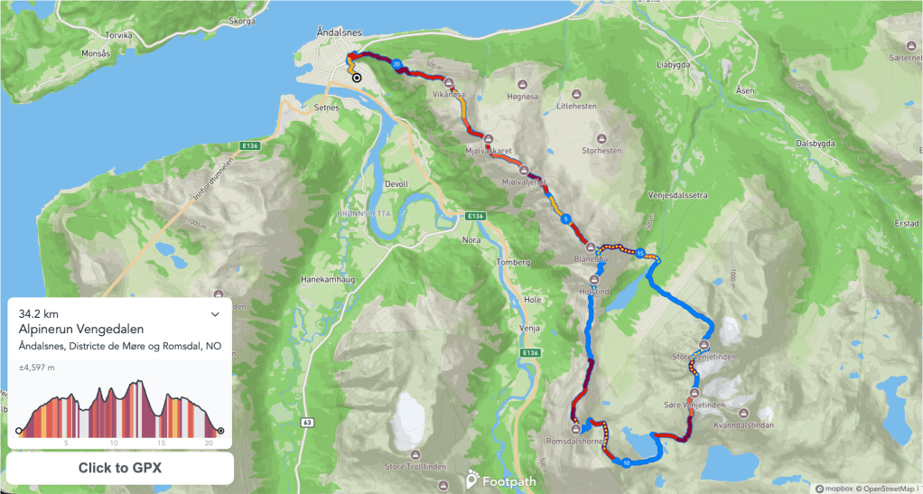
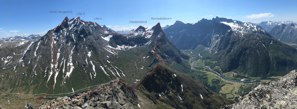
The Vengedalen Horseshoe (the traverse of Vengetind’s – Romsdalshorn – Blånebba, base of the route of the Alpinerun, is one of the most aesthetic ridgelines in the region, involving many kilometers of technical scrambling and climbing without descending to the valley.
The Romsdal Alpinerun is a run gathering alpinerunners to explore their physical and technical capacities in this beautiful skyline. The difficulties are up to grade IV (norwegian), 4b (french), 5.5 (YDS). It involves mountain climbing navigation and terrain. Even if the route is mostly in very solid rock, as alpine terrain it has some loose rock sections and natural hazards risks that requires the experience of the climbers.
ROUTE:
Road book:
- km 0-9: Romsdalseggen: Good trail, steep climb to Nesaksla (700m in 2km) then a ridge with a marked trail, some chains, til Blånebba. 💧There is very little water between Nesaksla and Høgaksla in some small rivers.
- km 9-10,3: ⚠️ Blånebba south ridge: downclimb, mostly following the edge of the ridge, some times climbing down Vengedalen side. grade III, exposed, some lose rock (+ info)
- km 10,3-13,5: Litlefjellet, good trail.
- km 13,5-14: ⚠️ Romsdalshorn Nordveggen: 400 meters of climbing, grade IV. Mostly solid rock, steep and exposed (+ info)
- km 14-15: ⚠️ Romsdalshorn normal route: downclimb following the south ridge til the marked pass (grade III, exposed) then downclimb the chimney Vengedalen side (grade III, steep) and follow the gully for some meters, downclimb on the left side of the gully and the face. Some stoneman mark the route. grade II. 💧There is some water at the bottom of the face, crossing the river.
- km 15-16: Olaskarstind Nord ridge: follow the ridge straight to the summit. grade II, some navigation.
- km 16-18: down Olaskarstind, some steps with hands at the top, then follow a trail til the lake Olarskarsvatnet. 💧Water at the lake.
- km 18-21: ⚠️ Vengetind Traverse: Up to Søre Vengetinden on a trail on steep lose rocks, then the ridge leaving the glacier to your right. From Søre Vengetinden follow mostly on the edge of the ridge, at places you can find easier terrain in either side of the ridge. After the marked pass, start climbing towards Lille Vengetinden, first a steep section from the pass and then by Kvannsdalen side (right side) to reach the edge of the ridge. Some exposed steps (grade II-III) to reach the top of Lille Vengetinden. From there downclimb following the edge of the ridge. It can be wet and exposed just before reaching Vestgjellet, the pass between the summits. At the pass, take the balcony, a ledge starting from the pass in the Kvannsdalen side (right) to contour the steep face. One joining the east ridge of Store Vengetind, follow it til the summit.
- km 21-23: Down from Store Vengetind by its normal route. The top section has some steps that are exposed, then follow the north ridge slabs until the marked skar. From there, a steep trail takes us down til Vengedalen. 💧 Some water in the downhill, and crossing the river at the bottom.
- km 23-25: ⚠️ 💧Cross the river by a bridge, then take the slabs climbing towards Blånebba, some steep steps in the upper part to reach the summit.
- km 25-34: Romsdalseggen down to Åndalsnes. Good trail.
RULES
- Participants will be self sufficient during the run, carrying all they need in gear, food and water withy them from the start.
- The date of the run will be decided inside the designated week (First week of July) to allow for best weather conditions.
- The days before the run, the participants must check the most technical sections of the route days before to familiarize with it and ensure they feel comfortable soloing it.
- Participants must have climbing insurance.
- There will be 10 participants (men and women combined). They will be selected from the previous year Alpinerun, races like Trofeo KIMA, Travesera de los Picos de Europa, Tour de Flatirons or from mountain FKT’s
- if you think you have it, send a letter telling why you want to participate here
